
La Plata County · Colorado
Village at Silverpick
An 85.92-acre, six-parcel assemblage on US Highway 550 in the Purgatory Resort corridor, north of Durango. The October 2025 concept plan programs six phases and approximately 217 to 242 residential units. The Consolidated Development Permit is in review.
The property
Planned, not yet permitted.
Village at Silverpick is an 85.92-acre assemblage of six parcels fronting US Highway 550 in La Plata County, Colorado, immediately south of the Purgatory Resort base area and bounded by San Juan National Forest to the north and Columbine Ranch to the west.
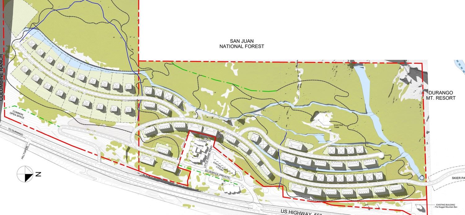
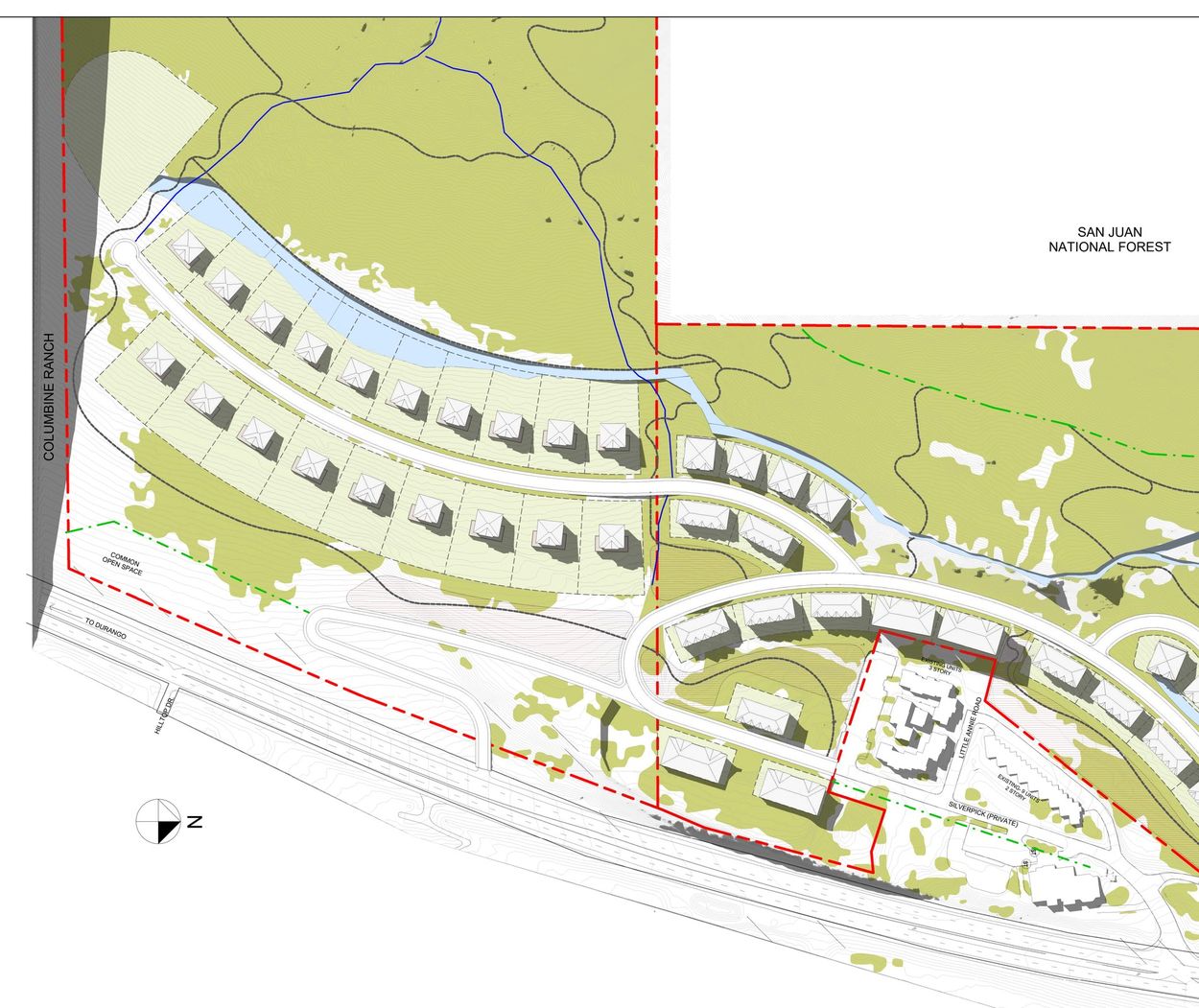
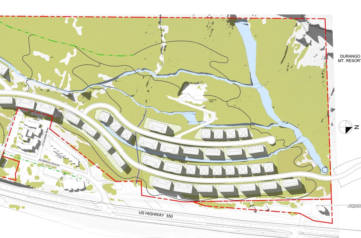
The land use concept plan, prepared by Juan Carlos Díaz, Architect and dated 30 October 2025, lays the program out in six phases running from the highway frontage northwest along the slope. Phases 1 through 4 are multifamily, including townhomes, and carry the great majority of the density. Phases 5 and 6 are single-family, roughly ten units each, at the far northwest end of the site.
An existing Silverpick development sits inside the assemblage — nine two-storey units and a group of three-storey units off Little Annie Road and the private Silverpick road — along with an existing water tank and, at the southeast corner, the Nugget Mountain Bar building. The concept plan works around all of them.
Nothing here is entitled. There is no recorded plat, no platted lot and no approved unit count. The Consolidated Development Permit application, La Plata County file PL20250133, is in review as of August 2026. Every figure on this page is a planning figure and will move.
Sourced facts
Land use concept plan
Six phases.
This is sheet U-01 of the concept plan. Select a numbered marker for the phase program, or jump to the multifamily or single-family end of the site and zoom in.
Sheet U-01, Land Use Concept Plan · Juan Carlos Díaz, Architect · 30 Oct 2025 · Drag to pan, scroll to zoom · Concept plan, not a survey or a plat
Phase schedule
What each phase carries
Land uses and unit ranges as shown on sheet U-01. Select a row to locate that phase on the plan above. No phase is platted, priced or released.
| Phase▾ | Land use▾ | Units, low▾ | Units, high▾ | Position on site | Plan colour | Type▾ |
|---|
Sheet U-01 totals the six phases at approximately 217 to 242 units. Sheet U-11, the unit-type breakdown, totals 217 units as drawn. The two agree at the low end of the range; the upper end is programmed capacity, not a drawn unit count.
Unit program
Four building types, 217 units as drawn.
From sheet U-11. The counts and percentages are the architect’s, not ours.
Lot sizes of 0.51, 0.61 and 1.62 acres. Phases 5 and 6, at the northwest end of the site.
Average lot size 0.085 acres. Two-storey house with a lower ground level.
Two-storey house with a lower ground level, approximately 1,660 sq ft plus the lower level.
Approximately 3,600 sq ft per unit, two units per floor, three-storey buildings.
Sheet U-11, Unit Types · Juan Carlos Díaz, Architect · 30 October 2025. The building counts multiply to 217 units exactly: 20 + (2 × 18) + (5 × 19) + (6 × 11). Unit sizes and lot dimensions are conceptual and precede civil engineering.
Entitlement and open items
What is not resolved yet
A professional will find these. Better they read them here first. Every item below is open as of August 2026.
The CDP is in review, not approved
Consolidated Development Permit PL20250133 is filed with La Plata County and under review. No unit count, density or land use on this page is approved. Approval was expected in the third or fourth quarter of 2026.
Supply is confirmed to roughly Phase 2 or 3
Existing Silverpick utility capacity, the on-site tank and current water rights cover the early phases. Full build-out at the programmed unit count requires supplementation through the Purgatory Metropolitan District. That supplementation is neither priced nor committed, and it can cap the program below the concept-plan count.
La Plata County’s determination is outstanding
Resort counties increasingly require an affordable or workforce set-aside. Whether Silverpick carries deed-restricted units, a fee in lieu, or neither has not been determined. It changes the program, not merely the cost.
There is no recorded plat and no lot
The interactive map on this page is an architect’s concept plan, not a survey and not a plat. Phase boundaries are illustrative. Nothing shown can be conveyed as drawn until platting follows the permit.
San Juan National Forest interface
The site abuts national forest on its north boundary. Wildfire exposure, defensible-space requirements and the cost and availability of project insurance in mountain Colorado are live diligence items.
Roughly a six to seven month window
At this elevation, horizontal work runs approximately May through November. Phasing, carry and delivery dates all have to absorb a winter shutdown.
The documents do not agree exactly
Sheet U-01 programs 217 to 242 units. Sheet U-11 draws 217. We publish both rather than pick the larger one.
An independent appraisal was outstanding
A third-party appraisal of the assemblage was commissioned and due at the end of August 2026. Until it lands, no value or pricing figure appears on this page.Update on receipt
Drawings
The rest of the plan set
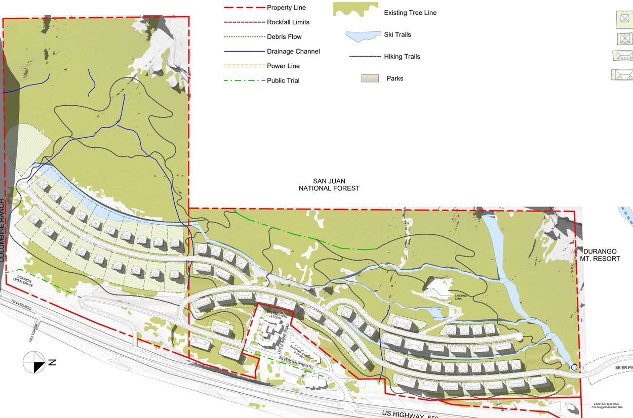
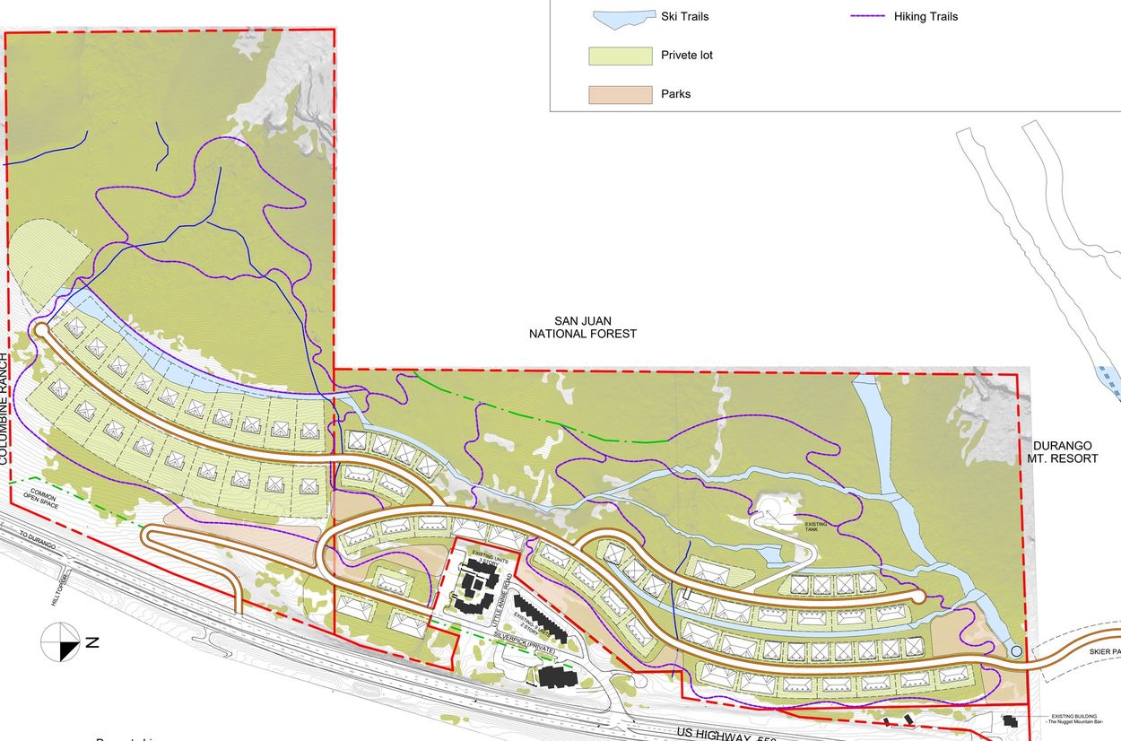
Sheets from the same October 2025 concept package. These are plan drawings, not survey documents.
Concept imagery — not photographs of the property
Concept imagery
What the plan looks like, drawn.
These are renderings, not photographs. Every image in this section is a three-dimensional model produced from the October 2025 concept plan. None of it is a photograph of the property, and none of it depicts an existing improvement.
Buildings, roads, trails, landscaping and terrain shown are illustrative, precede civil engineering and permitting, and will change. No site photography of the assemblage is published on this page.
The axonometric views come in two states for each vantage — the planned buildings alone, and the same model with the existing tree cover restored. Read them as a pair; that is the honest way to see how much of the site the program actually occupies.
For what governs, work from the plan sheets above and from the permit file, not from these images.
Location
On the highway, under the mountain.
The assemblage fronts US Highway 550 in the Purgatory Resort corridor north of Durango, with San Juan National Forest along its northern boundary, Columbine Ranch to the west and the resort immediately east.
Sheet U-12 routes ski trails from the buildable area toward the resort side of the site, and hiking trails through the retained open space. Access is from US 550 through the existing Silverpick and Little Annie Road network, with a separate emergency access shown at the southwest.
As labelled on the concept plan
Adjacencies and directions are as labelled on sheet U-01. Road distances and drive times are deliberately not published here. Measure them yourself, or ask and we will send the basis for any figure we do use.
Site location
37.6133
−107.8164
Approximate site centroid
La Plata County, Colorado
Diligence file
Everything this page relies on.
The documents behind every figure above. One short form, and it reaches a person rather than a list.
Inquiries
Three conversations we are having.
Every inquiry reaches a person at Triune Capital Partners. Call Justin at (281) 660-1133 or Ben at (469) 371-5106.
Builders & developers
Phase takedown
Pad and phase takedown structures, the full concept and engineering file, and the permitting timeline as it stands today.
Request the packageBrokers
Co-operating brokers
Registration, co-op terms and the marketing file. Listing representation in Durango is with SCB and Associates.Confirm before launch
Get the broker kitCapital & partnership
Start a conversation
Joint venture, land contribution and partnership discussions begin with a call. No offering material, terms or projections are published on this page or sent from this form.
Ask for a call